One day, months ago, we noticed a cell phone tower going up in our neighborhood. It was just off the main road, going out of our neighborhood the "back way". Fortunately, it was an Alltel tower (Which is who my service with my work cell phone is with). Now I have "full bars" in my house when I once was in constant roam.

Shortly after that thrill wore off, my wife and I were driving home and noticed another cell phone tower. We live on a dead-end road, at the end of it. So while driving to our house it just hit us and we looked up and there it was, in front of us. We don't remember seeing it being built or anything.
This fascinated me for days. At night, there were no lights so I assumed it wasn't active. I was hoping it was a sprint tower, since that is who my wife is with. One night, we saw the lights on and checked her phone... no dice... oh well.
So I had a day off a week or two ago (Or I didn't go into work, I can't remember which.) and figured "I am going to find the base of that tower."
 So I set out. My first goal was to drive to it. I mean, they didn’t just plop it in the middle of the woods, they had to have roads. So I got my GPS in hand and hipped in the truck ad drove to places in Emerald Mountain that I didn’t realize existed.
Once I found the tower, I decided to drive further past it. I instantly went into some time period about 60 years ago. I was on a dirt road, with old houses about an acre apart from each other. All owned by black farmers.
I felt unwelcome, as I am sure on this dirt road they know every person who lives down that way. So I marked the tower on the GPS and went back home.
Luckily, we have a great relationship with our next door neighbor (and their German Sheppard.) and since this tower was behind THEIR next door neighbor's home, I went into their backyard. Petted their German Sheppard, and hopped their back fence and set out.
 There was no trail. The first 10 yards was spent hunched over half the time, avoiding branches. It wasn't long before I came to a very large ditch. Being a lover of fishing, my heart foolishly leapt! I though "Water! Fish!" Stupid really, it was nothing more than a drainage ditch for the area I live in. Luckily, it hadn't rained in days, otherwise, the story would stop here.
So I climbed down this ditch. Had to have been 12 feet deep. I had to climb down. I slipped, and almost lost my ability to make any more children. Getting up was easier than coming down as God planted some trees and vines in just the right place. I noted some holes in the sides of this ditch. Opossums? Beavers? Racoons? Armadillos? Who knows? All of which have been spotted in the neighborhood.
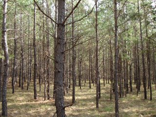
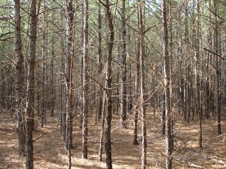
So upon climbing out from the ditch I was faced with a site that made me very glad I had my GPS (And glad I remembered to mark my home on it along with the tower. This area must have been a pine tree farm at one time. These trees were all the same size, and were planted at an angle... making everywhere I turned look the same. It was like a carnival fun house.
Looking at my GPS, I got the general direction to hike, and I set out. I couldn’t see the tower of course, too many trees. So many, in fact, that the GPS lost signal many times. I came to a small clearing, a radius of about 20 yards. You could tell deer laid here often (Another animal spotted in the neighborhood on an almost daily basis.) I took this opportunity to restart the GPS and get my location again. While I waited, I looked around and got spooked by what I saw... I saw a wooden structure... From where I stood, it looked like the side of a very old two story home. With VERY weathered wood. I thought about going to inspect it. Then thought better of the idea. Hobos man, hobos... I actually remember thinking that it might be a hidden Meth Lab and if someone is in there and they see me with a camera, they will try to kill me...

So I went for the tower again... Same deal with the trees, all alike. Yet not too much longer, a clearing came. It took me about 10 seconds to realize this was private property. The deer stands in the trees told me that. But I took a look around none-the-less. I could see the tower straight ahead of me, so I met that goal. This field was big, and there was Farm land on either side with horses, barns and all the other stuff youd find on a small farm...
I spent about 10 minutes snooping around and headed back... but not the way I came.
This new route took me closer to the wooden structure! And I was let down when I noticed it was a deer stand-hide. Then I got freaked out because I thought "People are deer hunting with rifles less than half a mile from my house?
All in all, it was a 1.5 mike hike in and out. I think I should
 contact the home owners assoc. about the deer stands in the woods...
Moral of the story; You can still find woods to explore. When I was a kid, I had an endless wood full of trails right in my back yard. I am glad I still have them, with the urban sprawl in this country; they are becoming a thing of the past. Of course, once Old Man deer Hunter gets the right price, he will sell all of his land and there will be homes back there instead of woods ...


12 comments:
That's cool, Jamison!
I still enjoy exploring the vast wooded areas around where my parents live.
There are still places in this country where you could get hopelessly lost, believe it or not.
Glad you had the GPS, dude!
I thought this was going to turn out to be something like "The Village". That's what I thought of seeing the trees & all.
Whoever owned that property with all the trees apparently had them planted for pulpwood.
My folks have about 40 acres of "farm" pines.
It's cool to walk through them, but definitely eerie.
I prefer walking though wild woods. You can find some crazy stuff in forests that have never been touched by industry.
Just consider The Indian Rock!
im blog-backed up... i have two more picture-full blogs to post, havent got around to them though...
stay tuned
I think I need a GPS thing. I took a partial exploratory walk a month or so ago. On the other side of the main drag running behind out house there is a small pond and a really big hill. I decided that I should see what’s going on over there. I crossed the street and started walking around the water. Not being one to want to take the easy road first I almost lost my very laced up timberlands in what I though would be firm shallow mud. I finally retreated and went around the mud hole and found a small chicken wired opening in very big rock where water was flowing out. I’m not sure if it is a spring of some sort or clean water run off but it was neat.
I looked up and trekked the hill before me reaching the top in no time. I eventually found myself at the entrance to one of the many and longest greenways in my wonderful city and feeling like I had warmed up a bit decided I should give it a go. I called Jules who was at work while the kids were visiting their grandparents and told her that I had hit the trail and that I’d wait for her at the other side a few miles from our house. The last time I did this trail I was on my bike and I really enjoyed it. It was nice to hit those markers remembering a turn, bend or overlook and things like that. As I made my way down I realized that it was very much dusk and that I should call Jules and tell her I was getting close to being done and maybe 20 minutes away from pick up. Twenty minutes later I wasn’t to the half way point on the home stretch and Jules wasn’t picking up her phone.
I spied the first stars overhead and relished their beauty without the sounds of traffic and civilized noises. The final stretch on bike took no time. The final stretch on foot too almost another 50 minutes. I figured that Jules phone had died or something and imagined her having to leave without me. As more and more stars popped out the temperature dropped very quickly. I had sort of planned with it being a cool day to begin with and wore a heavy hoody. Moving faster in hopes to get to the end I decided I’d pick up a bit of speed and began to sweat.
At long last I reached the end of the trail right as Jules was pulling up. Someone had needed her at work so she got out a bit later than usual, she had misplaced her phone and had no idea that I’d try to call her. In all it was about a two hour hike that was really great though very dark and cold at the end. I can’t wait to do it again, when it’s a bit warmer.
nice one Mullins... worthy of its own post id say... take a camera next time...
Garmin GPS are cheap. Dont go for the fancy ones... I have the standard yellow one (cant remember what it is called) and it can track you, you can creat waypoints, set flags at locations you want to get back to, hook it to a laptop with a map program and follow yourself, etc...
prob get one on ebay (like I got mine) for 70 to 90 bucks.... I love mine. Oh, and it helps you stay in shape. It is fune to see how many miles you walked and for how long... and to see your elevation haha.
That’s very cool. Wife, fetch me a GPS thing!
On this walk there are some pretty wonderful hills, as is on par with much of this area of east TN. There are a few moments on this trail where the view north is stunning. Breaks in the trees reveal the forward side of our valley neighbor Oliver Springs and some of its farming area. As the last big hill crests you can see into the distant backyard of the former K-25 plant which while it was helping build the bomb was the largest building in the world being a mile long “U” shaped structure.
A camera, yeah that would have been a good idea...
I just checked the Greenway website and found the walk is just shy of 6 miles and ranges between 760 and 1100 feet. Literally ¼ mile away from my back door. The other side of the trail head is still almost four miles away though.
Sorry I forgot to add the last leg of the trek, that trail is 7.5 miles.
I think this summer I’d like to do all the trails and be a Secret City Trekker. I can add my name to the website and everything!
I used to go to the blog of this guy in Seattle who was doing a city walk.
His plan was to walk every street in downtown Seattle. I don't remember how many miles that turned out to be, but it was significant.
The weekend after our gathering, we'll be having a music making close to Luverne. Hopefully, Jamison, Larissa, Rachel, and I can take a hike to the Indian Rock before the festivities!
Ah, yes... roughing it, becoming one with nature- with a cell phone, GPS tracker, and digital camera...
Just kidding! Technology good. Getting lost bad. Pictures good. Worried spouse bad.
I wonder how Luke would do hiking to the Indian rock? Just a thought.
I think Luke would love it!
You can actually drive up pretty close to it. From there, we could carry him over the roughest parts.
But, we'd need to keep a very close eye on him. Might be better to leave him with Mom afterall...
That sounds like so much fun, Jamison. It reminds me of being a little spout in Tennessee!
Post a Comment